THE
NATURE-BASED
SOLUTIONS
OPPORTUNITY SCAN
Leveraging Earth observation data to identify investment opportunities in nature-based solutions for climate resilience around the globe
![]() Bangkok’s Green Lung ©ESA
Bangkok’s Green Lung ©ESA
IN A NUTSHELL
The Nature-Based Solutions Opportunity Scan (NBSOS) is a tool designed for World Bank operations by the Global Program on Nature-Based Solutions for Climate Resilience (GPNBS) of the Global Facility for Disaster Reduction and Recovery (GFDRR). In about 6 weeks, NBSOS provides investment opportunities in nature-based solutions to reduce disaster risk and to build climate resilience. As the starting point for an investment plan, NBSOS results help the World Bank engage governments and stakeholders and to inform feasibility studies, design, and implementation.
CHALLENGE
Urban and coastal areas face significant pressures. Over half of the global population lives in cities, and more than a third resides within 100 kilometers of the coast. These areas are becoming congested, reducing green spaces and biodiversity, and negatively impacting well-being. Climate-related challenges such as floods, storms, extreme heat, erosion, and sea-level rise are increasing, leading to multi-billion-dollar losses annually.
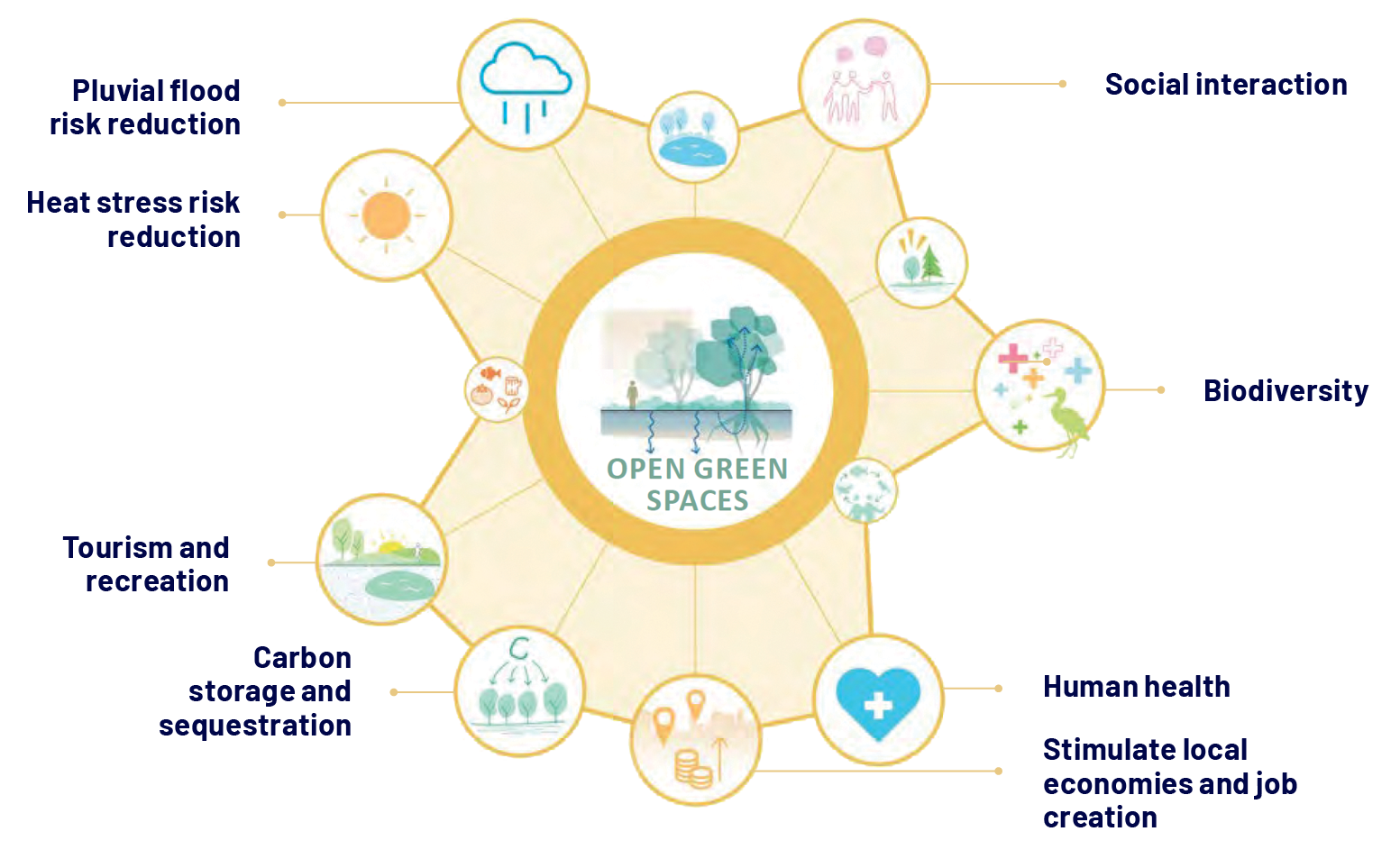
FIGURE 1: BENEFITS PROVIDED BY OPEN GREEN SPACES
Source: A Catalogue of Nature-Based Solutions for Urban Resilience, World Bank, 2021.
SOLUTION
Investing in nature-based solutions (NBS) through protection or restoration builds climate resilience. NBS are cost- effective and multifunctional, reducing risks while offering additional benefits like biodiversity, mental and physical health, food and water security, and local economic development. Examples include preserving wetlands, mangroves, and coral reefs; restoring watercourses and vegetated dunes; and creating open green spaces in cities (Figure 1). Integrating NBS with gray infrastructure projects can maximize benefits.
NEED
Timely, actionable information is essential to scale up NBS investments. Governments and the World Bank need accurate data to identify, design, and implement NBS projects. Understanding NBS investment opportunities early in the identification phase is crucial for greening infrastructure and enhancing climate resilience. Without such information and the right technical expertise, projects often revert to traditional gray infrastructure.
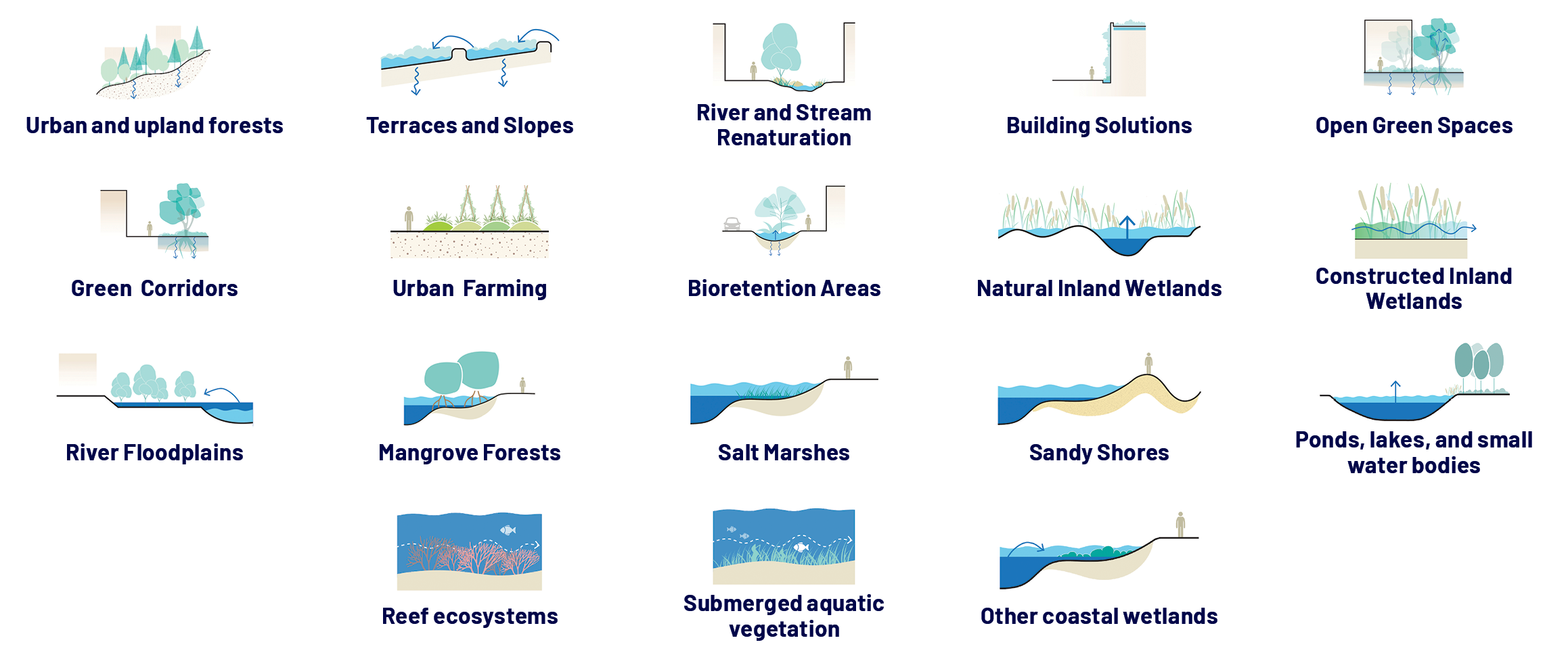
FIGURE 2: TYPES OF NATURE-BASED SOLUTIONS IN URBAN AND COASTAL AREAS
Source: Adapted from A Catalogue of Nature-Based Solutions for Urban Resilience, World Bank, 2021.
TOOL
NBSOS supports the World Bank, its clients, and development partners in identifying NBS investment opportunities and understanding their benefits for communities and the environment. It supports the integration into investment project financing, addressing the demand from project teams and government decision-makers lacking essential information on NBS typologies, priority areas, costs, and benefits. Primarily used in the investment identification phase, NBSOS provides NBS opportunities and their resilience- building benefits in urban or coastal areas. It also supports strategic diagnostics, such as in Country Climate and Development Reports and climate change adaptation planning, for cross- sectoral investment prioritization.
NATURE-BASED SOLUTIONS DEFINED
Nature-based solutions (NBS) is an umbrella term referring to “actions to protect, conserve, restore, sustainably use and manage natural or modified terrestrial, freshwater, coastal and marine ecosystems, which address social, economic and environmental challenges effectively and adaptively, while simultaneously providing human well-being, ecosystem services and resilience and biodiversity benefits” (United Nations Environment Assembly, 2022).
APPLICATION
NBSOS is a geospatial analysis and participatory process offered by GFDRR as an on- demand service in World Bank engagements worldwide. NBSOS is applied at the request of and in collaboration with World Bank operations teams and their clients. It is tailored to each case to offer the most pertinent guidance.
In about 6 weeks, NBSOS provides a comprehensive package including geospatial data, hazard maps, NBS opportunities, benefit analyses, prioritization, scenarios, cost-benefit assessments, interpretations, and investment recommendations. World Bank teams receive direct access to a presentation folder, ongoing support and guidance from the Global Program on Nature-Based Solutions for Climate Resilience (GPNBS) team, and a user- friendly online geospatial Viewer application (map 1).
MAP 1: NBSOS VIEWER’S APPLICATION IN ACCRA, GHANA. THE TOP MAP HIGHLIGHTS HEAT PRIORITY AREAS, WHILE THE BOTTOM MAP DISPLAYS NBS INVESTMENT OPPORTUNITIES.
Source: NBSOS, World Bank|GFDRR 2024
STEP 1: UNDERSTANDING THE PROBLEM
Priority areas for investment within the city are identified by looking at where the resilience and sustainability challenges are most prevalent. The urban NBSOS assesses where to implement NBS to reduce pluvial flooding; where to mitigate extreme heat; and where there is a need to increase access to green space, which is assumed to provide health, recreation, and social cohesion benefits to communities. The priority areas for each challenge can be visualized by clicking the corresponding checkbox. Opacity can be changed using the slider bar.

BOX ❶ URBAN RESILIENCE IN SENEGAL
NBSOS identified key climate risks in Dakar, such as East Dakar’s pluvial flooding and central zones’ heat stress. Suitable NBS include bioretention areas in West and East Dakar, urban forests and green corridors in the East of city, and green roofs and facades in high-density central zones. NBSOS demonstrated the potential benefits of these solutions in terms of flood reduction, heat mitigation and social cohesion.
NBSOS has helped the World Bank and the government of Senegal with the identification of investment locations and typologies of urban nature-based solutions. Such investments will potentially be integrated alongside grey infrastructure investments in Dakar’s urban resilience program financed by the World Bank. In addition, the most cost-effective solutions will be included as climate adaptation investment needs in Senegal’s Country Climate and Development Report, a strategic climate diagnostic developed by the World Bank.
APPROACH
NBSOS uses 10-to-30-meter resolution global geospatial data and a sophisticated methodology to map the potential benefits of NBS and identify investment opportunities in cities and along coastlines anywhere in the world. NBSOS follows a hierarchical approach to NBS interventions, prioritizing the protection of existing ecosystems over enhanced management, rehabilitation, and restoration, and finally the creation of new NBS.
METHODOLOGY
NBSOS analysis involves four steps (map2):

PROBLEM
ANALYSIS:
Assess the magnitude and spatial variation of climate resilience challenges and natural hazards.

SUITABILITY
MAPPING:
Identify suitable areas for the protection and creation of NBS types.

BENEFIT
MODELING:
Estimate the positive impact of NBS on identified challenges and hazards.

DECISION
SUPPORT:
Determine optimal NBS investment distribution to maximize benefits using multicriteria or cost- benefit analysis, providing crucial information to decision-makers.
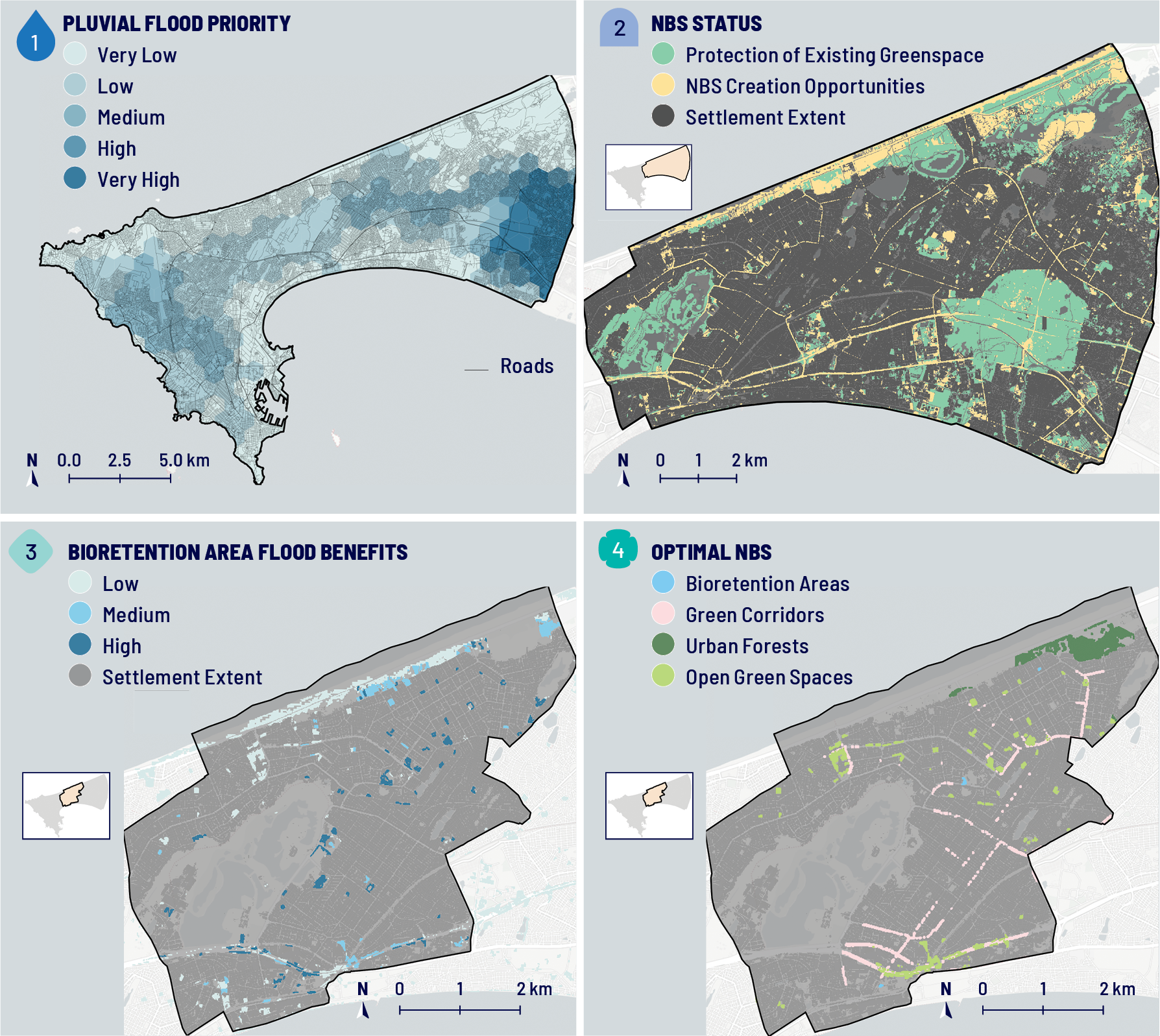
MAP 2: NATURE-BASED SOLUTIONS OPPORTUNITY SCAN IN DAKAR, SENEGAL: SELECTED MAPS FOR THE 4 STEPS OF NBSOS.
1 – Flood priority area identification. 2 – NBS suitability mapping. 3 – Flood benefits from bioretention areas. 4 – Optimal NBS families.
Source: Adapted from A Catalogue of Nature-Based Solutions for Urban Resilience, World Bank, 2021.
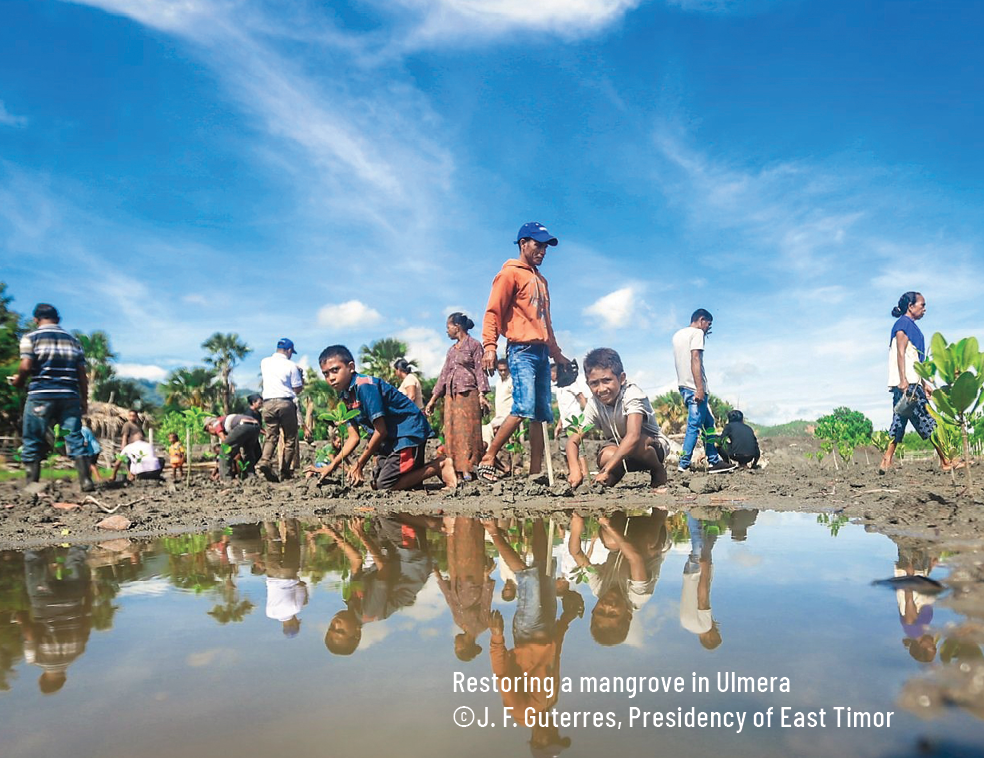
BOX ❷ COASTAL RESILIENCE IN TIMOR LESTE
NBSOS identified coastal areas vulnerable to coastal flooding and sea-level rise. Suitable coastal NBS include the protection and restoration of coral reefs, mangroves, and sandy beaches, which all protect the shoreline and provide other benefits such as nature-based tourism, providing habitat for commercially important fish species and carbon storage and sequestration. Based on the combination of these benefits, priority areas for ecosystems conservation and restoration were identified.
NBSOS has been instrumental to start the conversation about coastal nature-based solutions between the World Bank and the Government of Timor- Leste. For example, NBSOS’ spatial analysis on the value of coral reef preservation to protect coastlines, fish stocks and tourism revenue is used to inform the policy dialogue about strategic identification of additional marine protected areas.
IMPACT
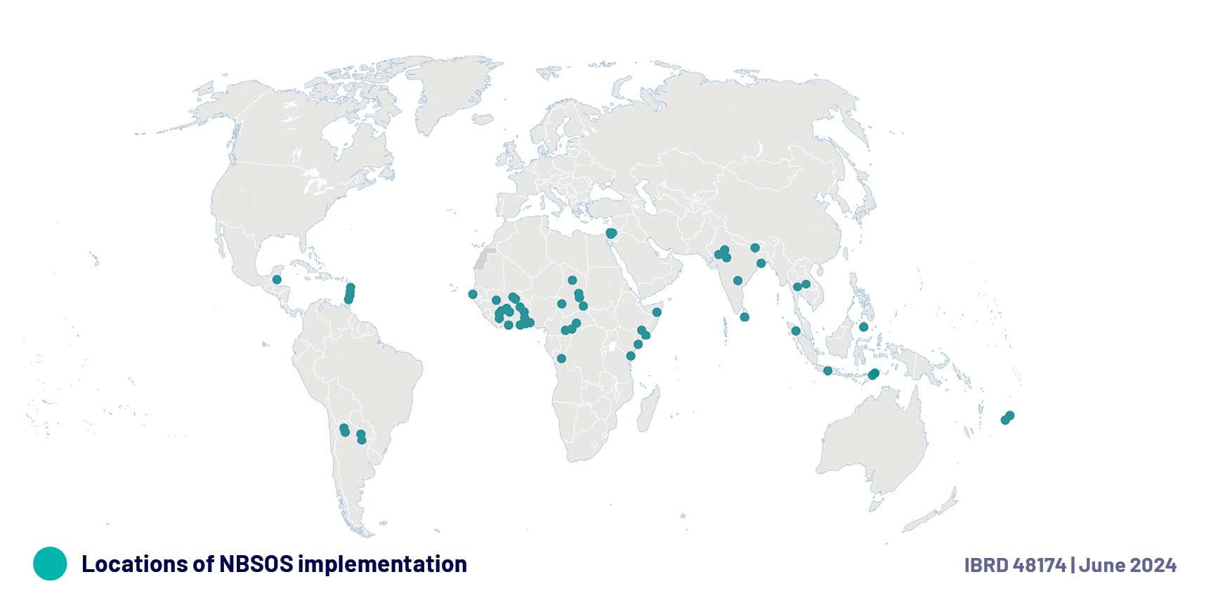
Between mid-2022 and early 2024, NBSOS was successfully implemented in 20 countries, spanning various regions and sectors, including 8 coastal landscapes and 51 cities (map 1 & 2), informing $2.3 billion in development financing and key strategic assessments.
NBSOS helped World Bank project teams to:
![]() Identify NBS opportunities.
Identify NBS opportunities.
![]() Assess costs and benefits, prioritize, and start investment plans.
Assess costs and benefits, prioritize, and start investment plans.
![]() Engage with local stakeholders and communities.
Engage with local stakeholders and communities.
![]() Shape feasibility studies, design, and implementation.
Shape feasibility studies, design, and implementation.
Most projects informed by NBSOS are investment project financing engagements, also used to identify NBS for Country Climate and Development Reports. NBSOS is more impactful at the project level if supported by the GPNBS, which supports World Bank operations teams presenting, interpreting, and integrating results into feasibility studies and design.
NEXT STEPS
NBSOS is continuously learning and improving. Feedback from field operations along with academic innovations enable NBSOS to stay at the cutting edge of science while quickly delivering effective results in operational contexts. Analytical improvements will focus on expanding the capability of the NBSOS estimating biodiversity impact and quantifying pluvial flood reduction. Efforts are also underway to estimate unit costs of urban NBS and develop rapid costing tools.
NBSOS seeks to maximize impact and increase capacity, improving efficiency, standardizing processes, and enabling replicability to meet the growing needs of the World Bank’s operational teams. To maximize NBS implementation worldwide, efforts are also being made to explore how the service model can be extended for development partners.
CONTACT
LEARN MORE ABOUT THE NBSOS!
For additional NBSOS information, please connect to our website and contact us.